|
The Importance of Rivers
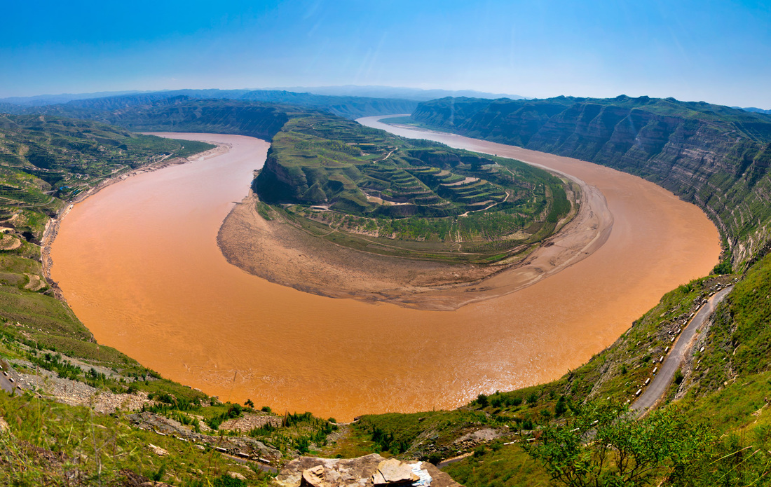
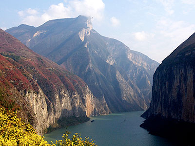
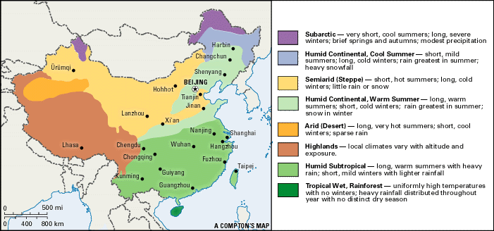
There are two major rivers in China. The Huang Ho was one of them. It means "Yellow River". This was also the most northern River in China. It's name comes from the yellow slit it carries from the plains and the Gobi dessert. The other major river,located farther south, is called the Chang Jiang or "Long River". It cuts deep gorges through mountains before it begins its slow run through the plains. Both rivers provided early peoples with transportation routes, water for washing and drinking, and water for irrigating crops. The earliest and most powerful societies developed along the Chang Jiang and the Huang Ho. The settlements along the Chang Jiang were eventually joined to those of the Huang Ho. One of these settlements,Zhengzhou, might have been the site of the first Shang capital. During the Shang dynasty, the capital was moved several times. Around 4000 BCE,Neolithic farmers began to settle in the northern plains of China near the Huang Ho River. The land was covered in yellow dust, called loess. The loess was very fertile when it was irrigated, which made it good soil for farming. The dust was brought into the area in two ways.(1) The loess was ground into fine particles by the glaciers and carried then deposited on the plains by the wind.(2) The Huang Ho River, which runs through the plains, carried the dust and deposited it on the farmland whenever the river flooded. Neolithic farmers began to grow millet and later,rice in this soil.The Huang Ho River provided abundant water for crops, but also subjected the people living along its banks to terrible floods. At other times, there were periods of drought , or shortages of water. The importance of the river and its unpredictability made it necessary for the Chinese to learn how to build dikes,dams,canals, and irrigation systems to control their water resources. Land/Topography The geography of Ancient China shaped the way the civilization and culture developed. The large land was isolated from much of the rest of the world by dry deserts to the north and west, the Pacific Ocean to the east, and impassable mountains to the south. This enabled the Chinese to develop independently from other world civilizations China is a vast country, located in the eastern part of the Asian continent, on the western Pacific Rim. It is the world's fourth largest country covering an area of 9.6 million square kilometers. With additional offshore territory, including territorial waters, special economic areas, and the continental shelf, China's overall territory covers almost 13 million square kilometers. China topography varies greatly from highly mountainous regions to inhospitable desert zones and flat, fertile plains. It can be compared to a staircase descending from west to east. The Tibetan Plateau forms the highest part of the country (the first step). Known as the 'roof of the world', the Tibetan-Qinghai Plateau is more than 5,000 feet above sea level. The Himalayan mountain range has a number of peaks over 23,000 feet, with the tallest in the world, Mount Everest, at the Sino-Nepalese border, Melting snows from these peaks are the source of several of the main Chinese rivers including the Yangtze and the Yellow River which run from west to east. Climate China is a vast country with many different weather systems. The climates in China range from tropical to high altitude, polar conditions. A tropical climate is found on Hainan Island. Usually there is a large amount of rainfall during the summer months. Average temperatures are 21 degrees celsius in the winter and 38 degrees celsius in the summer. From March to November the weather becomes very hot and humid. In the South East there is usually a very hot, humid summer with a maximum temperature of 38 degrees celsius. The winters are mild and drizzly with a minimum temperature of 10 degrees celsius. The coast is often struck by typhoons between July and September. The winters in the North East are exceptionally cold with temperatures as low as -40 degrees celsius. The summers are hot and dry reaching a maximum of 35 degrees celsius. There is a similar climate in the southwest. In the central areas winters are short and cold with temperatures falling below zero.Summers are long, hot, and humid. Flooding has become a problem in recent years. Wuhan,Nanjing and Chongqing are known as "the three furnaces" because of the heat in the summer. The North West desert and steppe is arid. The region has scorching hot, dry summers with temperatures reaching 45 degrees celsius in Turfan. Winters can be just as bitter as in the North East, although the average temperature is -10 degrees celsius. The Tibetan plateau is very dry all year round because of the altitude. Summer days can be warm and reach about 25 degrees celsius. However, at night it can be bitterly cold and the temperature can fall below zero. Winters are extremely cold with fierce winds making it seem much colder than the average -10 degrees celsius. |
